
Location/Site
Indian Head Canyon Open Space
(33°04’27.16″N 117°17’05.83″W)
Date
July 3rd, 2026
Time
07:57 AM
Executive Summary
Mission Objective
Develop a spatial dataset of a natural, undeveloped open space area using a 90º crosshatch pattern with East-West and North-South passes, captured with nadir imagery. This mission will serve as a basis for comparison with Mission 3A.
Like 3A, the purpose of this mission is to examine the capture of natural vegetation on a hilly site using a fixed AGL with enhanced crosshatch capture. The elements of focus are:
- Data quality of different elevations on the site using a fixed AGL and determining whether there is sufficient overlap.
- The site’s data quality with the additional crosshatch pattern
- Vegetation detail in the orthomosaic
- Topography detail in the point cloud and textured mesh
Mission success will be defined as the creation of a complete orthomosaic, point cloud, and DSM with minimal visible distortion, occlusions, and reproduction errors.
Intended Applications
- Site documentation
- Relative dimensional verification
- Pavement, vegetation, and asset inventory
- Existing conditions documentation
- Baseline comparison for future site monitoring
- Capture strategy evaluation
Mission Planning
Airspace
- Class G, Uncontrolled
- No TFRs
Weather Conditions
- Temperature: 64.4º F
- Wind: 4.3 mph, 297º NW
- Cloud Cover: BKN, 1000’ AGL
- Lighting Conditions: Overcast, intermittent sun
- Visibility: Excellent – 6 miles
Mission Success Criteria
- Complete image alignment
- Continuous orthomosaic coverage
- Minimal visible block deformation
- Relative measurements within ±5% of field measurements
- Clearly documented dataset limitations
- Safe and complete mission without any deviations or conflicts
Data Capture Strategy
Flight Parameters
| Parameter | Value |
|---|---|
| Flight Pattern | Automated 90º Crosshatch Grid (2 flights, manually created) |
| Altitude | 150 ft AGL |
| Flight Duration | 42m 06s |
| Camera Angle | Nadir (-90°) |
| Front Overlap | 80% |
| Side Overlap | 65% |
| Speed | 3.13 mph |
| Photo Interval | 5 sec |
| ISO | 100 |
| Shutter | 1/640 sec |
| Aspect Ratio | 4:3 |
| Image Capture Count | 441 JPEG (8064 x 6048) |
| Lighting | Broken clouds |
Processing Summary
| Metric | Result |
|---|---|
| Images Reconstructed | 441/441 shots (100.0%) |
| Average Reprojection Error | 1.65 px |
| Average GSD | 1.0 cm/pixel |
| Sparse Points | 458,400/462,172 points (99.2%) |
| Dense Points | 37.25 million |
| GPS Source/ CRS | Consumer GPS/WGS84 (No RTK/PPK) |
| GPS Error RMS | .77 meters |
| Outputs | Orthomosaic, DSM, DTM, Point Cloud, Mesh |
Interpretation
Orthomosaic
Produced complete visual coverage of the project area with no significant stitching failures. The orthomosaic would be suitable for documentation and visual inspection.
Point Cloud
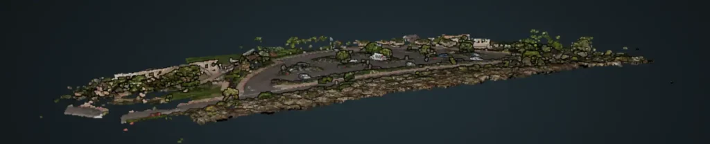
Successfully reconstructed terrain and vegetation. Areas beneath tall vegetation were occluded due to the nadir acquisition strategy. Thin branches did get reconstructed.
Textured Mesh
Produced a coherent three-dimensional representation of the site. Quality decreased beneath mature trees and along vertical surfaces where image geometry was insufficient.
DSM
Successfully represented overall site topography, including the gradual elevation increase across the parking lot. Vegetation was roughly preserved, as expected, in the Digital Surface Model. The DSM provided a relative elevation scale for the site.
Quality Assessment
Strengths
- Complete image reconstruction
- Uniform lighting provided strong detail and color
- Minimal large-scale block deformation
- Repeatable acquisition workflow
Limitations
- Absolute positional accuracy limited by consumer GNSS
- Dataset unsuitable for engineering-grade positioning
Quality Validation
Relative Measurement Validation
Since the purpose of this mission is to examine the capture of natural vegetation on a hilly site using a fixed AGL, the emphasis was not on comparing measurement accuracy but rather on comparing coverage across different elevations on the site. No measurements were taken for verification
Although GNSS corrections were not used, the model was evaluated against local coordinates, datum, and elevations to assess absolute accuracy.
Conclusion
This dataset was acquired using nadir imagery via two 90º crosshatched lawnmower patterns at a constant altitude of 150’ AGL from the launch site. This mission also had a constant AGL, so the flight elevation was slightly low (99′ AGL) at the highest point of the mapping area. This resulted in a weaker side overlap of 51% and a theoretically weak reconstruction of the model’s western edge (Saxony Rd.). Yet, with the crosshatch pattern, the Survey Data showed improved coverage of all elevations of the site.
The purpose of this mission was to test the Mini 4 Pro’s ability to capture a larger area with varied terrain while preserving detail in natural vegetation. Since this was a natural open space without clear man-made structures or markings,, I did not focus on validation measurements for relative accuracy.
The orthomosaic provides excellent visual coverage of the site. Around the perimeter of the site, there is some occlusion beneath the larger trees and shrubs, and some smaller branches were not reconstructed in the 3D point cloud, but overall, there is good visual detail of the vegetation, terrain, and bordering roads.
A comparison with the noted spot elevations provided by the City of Encinitas indicates a significant shift of approx. 60’ in vertical positioning. Again, a lack of absolute accuracy is expected with consumer GPS without GNSS corrections, but the degree of inaccuracy is greater than expected.
This dataset is suitable for progress status, inventory assessment, drainage, horizontal surface inspection, and approximate measurements, but would not be adequate for engineering, surveying, or construction-grade decision-making.