
Location/Site
Encinitas Community Park NE ball fields parking lot
(33°01’53.10″N, 117°16’45.08″W)
Date
June 17, 2026
Time
8:24 AM
Executive Summary
Mission Objective
Develop a spatial dataset of a municipal parking lot using a lawnmower pattern with 4 longitudinal passes to capture nadir imagery. The single variable change to this flight will be increasing the AGL to 200’.
Mission 1B will compare model reconstruction to that of Mission 1A. The mission was designed to compare DSM, visual accuracy, and image overlap at higher altitudes for producing an orthomosaic, a dense point cloud, a textured mesh, and a digital surface model, while accounting for the limitations of consumer-grade GNSS positioning.
Intended Applications
Potential applications include:
- Site documentation
- Relative dimensional verification
- Pavement, asset, and vegetation inventory
- Existing conditions documentation
- Baseline comparison for future site monitoring
- Capture strategy evaluation
Mission Planning
Airspace
- Class G, Uncontrolled
- No TFRs
Weather Conditions
- Temperature: 66.2º F
- Wind: 3.1mph, 331º NW
- Cloud Cover: BKN, 1000’ AGL
- Lighting Conditions: Overcast
Mission Success Criteria
- Complete image alignment
- Continuous orthomosaic coverage
- Minimal visible block deformation in the point cloud
- Relative measurements within ±5% of field measurements
- Clearly documented dataset limitations
- Safe and complete mission without any deviations or conflicts
Data Capture Strategy
Flight Parameters
| Parameter | Value |
|---|---|
| Flight Pattern | Automated Lawnmower Grid (manually created) |
| Altitude | 200 ft AGL |
| Flight Duration | 13m 30s |
| Camera Angle | Nadir (-90°) |
| Front Overlap | 88% |
| Side Overlap | 79% |
| Speed | 3.13 mph |
| Photo Interval | 5 sec |
| ISO | 100 |
| Shutter | 1/800 sec |
| Aspect Ratio | 4:3 |
| Image Capture Count | 117 JPEG (8064 x 6048) |
| Lighting | Uniform Overcast |
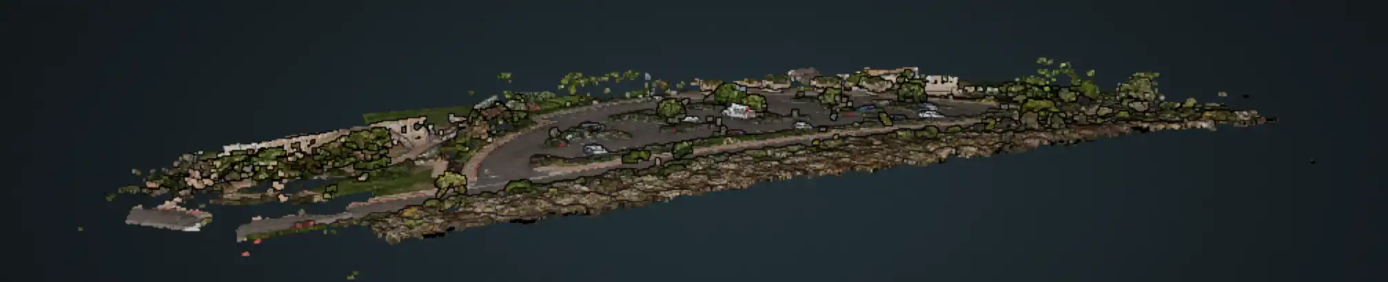
Processing Summary
| Metric | Result |
|---|---|
| Images Reconstructed | 117 / 117 |
| Average Reprojection Error | 1.6 px |
| Average GSD | 1.0 cm/pixel |
| Sparse Points | 124,622 (98.9%) |
| Dense Points | 16.3 million |
| GPS Source/ CRS | Consumer GNSS (No RTK/PPK) |
| GPS Error RMS | .25 m |
| Outputs | Orthomosaic, DSM, DTM, Point Cloud, Mesh |
Interpretation
Orthomosaic
Produced complete visual coverage of the project area with no significant stitching failures. Higher altitude improved overlap, and stitching errors decreased compared to Mission 1A. Suitable for documentation, visual inspection, asset inventory, and approximate measurements.
Point Cloud
Successfully reconstructed terrain, pavement, vegetation, and major structures. The sparse point clouds were well constructed with 99% of the reconstruction points. As expected, building facades, vehicle sides, and tall vegetation were incompletely represented due to the nadir acquisition.
Textured Mesh
Produced a coherent three-dimensional representation of the site. Quality decreased beneath mature trees and along vertical surfaces where image geometry was insufficient. Pavement melted into the vertical surfaces of vehicles.
DSM
Successfully represented the overall site topography, including the gradual increase in elevation and the contours across the parking lot.
Quality Validation
Relative Measurement Validation
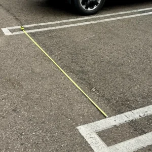
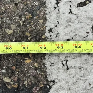
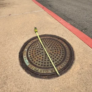
Seven independent field measurements were compared against the reconstructed model.
Results demonstrated relative dimensional agreement generally within approximately 2–5%. Similar to Mission 1A, there was one outlier associated with a table abutting a tall fence, resulting in incomplete capture and measurement inaccuracies.
Note: Actual measurements for “SE-NE Lightpost pad” and “SW Curb to White water pipes” were taken from Google Earth and may have absolute inaccuracies of 1’ to 5’.
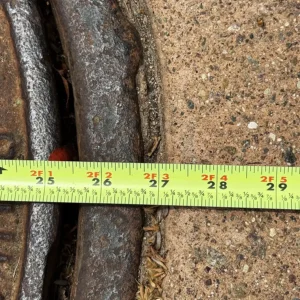
| Location/object | Lat/Long Coordinates | Actual (inches) | Model (inches) | Delta (Inches) | Signed Error (%) | Model Used |
|---|---|---|---|---|---|---|
| Launch area parking stall | 33°01'53.00"N 117°16'45.06"W | 92.125 | 92.12 | -0.005 | -0.01% | Ortho |
| Slab near the building | 33°01'52.40"N 117°16'46.43"W | 123 | 125.98 | 2.98 | 2.42% | Ortho |
| North sidewalk | 33°01'55.60"N 117°16'46.51"W | 185.75 | 191.33 | 5.58 | 3.00% | Ortho |
| East sidewalk | 33°01'52.34"N 117°16'44.17"W | 89.75 | 90.27 | 0.52 | 0.58% | Ortho |
| Baseball table | 33°01'50.68"N 117°16'43.70"W | 35.75 | 33.75 | -2 | -5.59% | Ortho |
| Manhole cover | 33°01'51.21"N 117°16'44.70"W | 27 | 25.69 | -1.31 | -4.85% | Ortho |
| Dark sidewalk (SW) | 33°01'51.20"N 117°16'45.51"W | 47.5 | 47.47 | -0.03 | -0.06% | Ortho |
| SE-NE Lightpost pad | 33°01'55.4"N 117°16'46.0"W 33°01'51.2"N 117°16'42.7"W | 504 | 505.46 | 1.46 | 0.29% | Ortho |
| SW Curb to White water pipes | 33°01'53.0"N 117°16'44.3"W 33°01'52.2"N 117°16'46.8"W | 234 | 234 | 0 | 0.00% | Ortho |
| Error Calculation | Value |
|---|---|
| Mean Signed Error (Bias) | -0.53% |
| Mean Absolute Error (MAE) | 1.54 |
| Mean Absolute Percent Error (MAPE) | 1.87% |
| Root Mean Square Error (RMSE) | 2.45 |
This dataset is suitable for educational use and approximate measurements but lacks the positional accuracy required for engineering, surveying, or legal-grade geospatial analysis.
Quality Assessment
Strengths
- Complete and improved image reconstruction
- Minimal stitching and warping
- Consistent relative measurement accuracy
- Uniform lighting enhanced detail
- Repeatable data capture workflow
Limitations
- Absolute positional accuracy limited by consumer GNSS
- Missing vertical surfaces
- Under tree occlusions
- Vehicle movement introduced localized artifacts
- Dataset unsuitable for engineering-grade positioning
Conclusion
This mission successfully compared 200’ vs 120’ altitude data capture. It demonstrated that, at increased altitudes, DSM remained well within an acceptable measurement range. There was an improvement in the RMSE during the measurement validations, which may have been due to increased overlap and coverage, thereby improving the relative positioning and geometry of the reconstruction.
This dataset is suitable for progress status, inventory assessment, horizontal surface inspection, and relative approximate measurements, but would not be adequate for engineering, surveying, or construction-grade decision-making.
Mission 1C Hypothisis
Mission 1C will include additional capture with a 90º crosshatch pattern at 120′ which should improve the relative accuracy and positioning.